Finding your way inside large buildings shouldn’t feel like solving a puzzle on a deadline. Yet anyone who has dashed through an unfamiliar airport, wandered a hospital in search of the right clinic, or tried to meet a friend inside a vast arena knows how quickly confidence evaporates when signs conflict, corridors are closed, or crowds surge in unexpected directions. Traditional wayfinding static maps, fixed arrows, and wall-mounted directories was built for a slower world. Modern buildings change layouts for events, reroute flows during maintenance, and rely on assets like escalators and elevators that occasionally fail. The result is a guidance gap at precisely the moment people most need clarity.
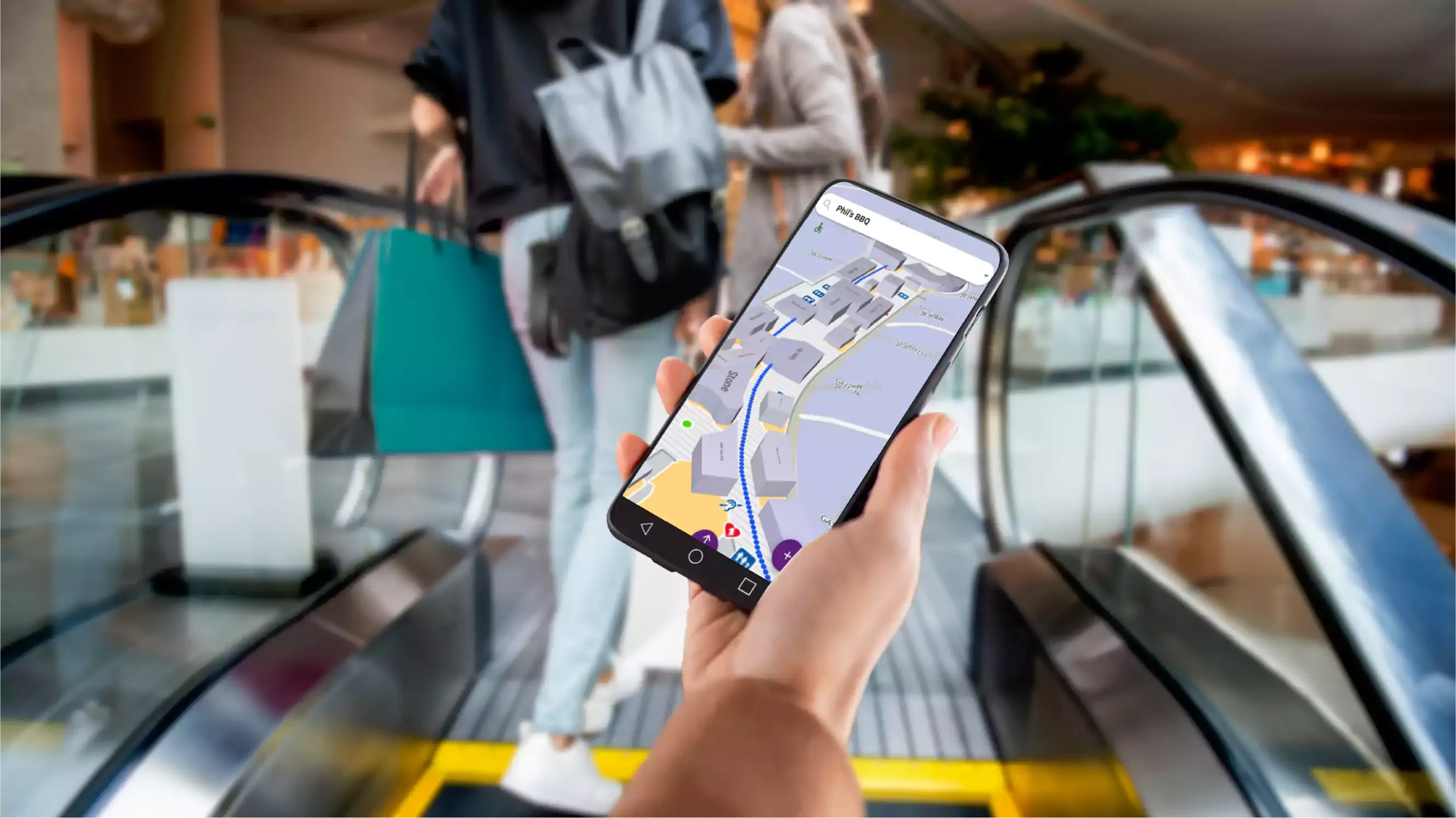
Indoor navigation, sometimes called “digital wayfinding”, closes that gap by turning floor plans into living systems. It blends positioning, mapping, and real-time context so directions reflect what is happening right now, not what was true when a sign was printed. The aim is simple: reduce friction for visitors and reduce firefighting for operators.
Why the “blue dot” inside a building is hard and why it matters
Outdoors, satellite signals make turn-by-turn navigation feel effortless. Indoors, those signals degrade and bounce, and the physical environment changes constantly. This is why reliable indoor positioning “blue dot” that doesn’t drift or spin is both harder to achieve and more valuable once it works. A dependable position enables natural, human-level guidance: telling someone to turn left after the café rather than asking them to march precisely seventeen meters. It also underpins true indoor navigation, where routes adapt mid-journey if an escalator stops, a lift is congested, or a corridor becomes temporarily inaccessible.
A modern indoor positioning system typically combines multiple signals. Existing Wi-Fi and Bluetooth beacons can contribute, and in high-stakes areas the venue may add a small number of privacy-first sensors at choke points or key junctions to improve accuracy. The goal isn’t to track identities; it’s to understand movement. When the system knows where a device is with confidence, every subsequent decision from which path to suggest to whether to reroute gets better.
From static floor plan to live maps
The second pillar is an indoor map that behaves like a digital twin rather than a picture. In a digital twin, corridors, lifts, stairs, rooms, and entrances are represented as a connected graph, not just shapes on a page. That graph can be updated as the building evolves, and it can absorb live signals. If a lift is reported out of service, the graph marks that edge as unavailable for step-free routes. If sensors detect a buildup of people at a corridor near security, the system infers that travel time has increased and will route newcomers along a quieter path. In other words, the map understands what the building is doing right now.
On top of this map sits a routing engine that thinks like a guide. It weighs distance, accessibility, current congestion, and even preferences such as avoiding noise or choosing gentler gradients. When conditions change mid-journey, the engine quietly adapts rather than forcing the visitor to backtrack. The best systems make this feel calm rather than clever; the point is to remove decisions, not to showcase complexity.
What a great indoor navigation experience feels like?
For the visitor, confidence arrives early and stays. The blue dot anchors to the right floor, the route instructions are written in the language people actually use, and the system reacts gracefully when plans change. Someone arriving late to a clinic sees a route that respects step-free requirements without detours that exist only on paper. A traveler with a tight airport connection receives a path that accounts for an unexpected queue outside security and gently nudges them toward an under-used lane. A museum guest who prefers quieter spaces can be guided along a sequence of corridors that avoids crowded galleries while still reaching the exhibition they came to see.
All of this only works if accessibility is built in rather than bolted on. True accessibility goes beyond “avoid stairs.” It considers elevator reliability, slope and distance between waypoints, the presence of rest areas, and the ability to choose calmer paths. When these options are modeled directly in the map and routing engine, they stop being special cases and become the default for anyone who needs them.
Why operators value indoor navigation as much as visitors do?
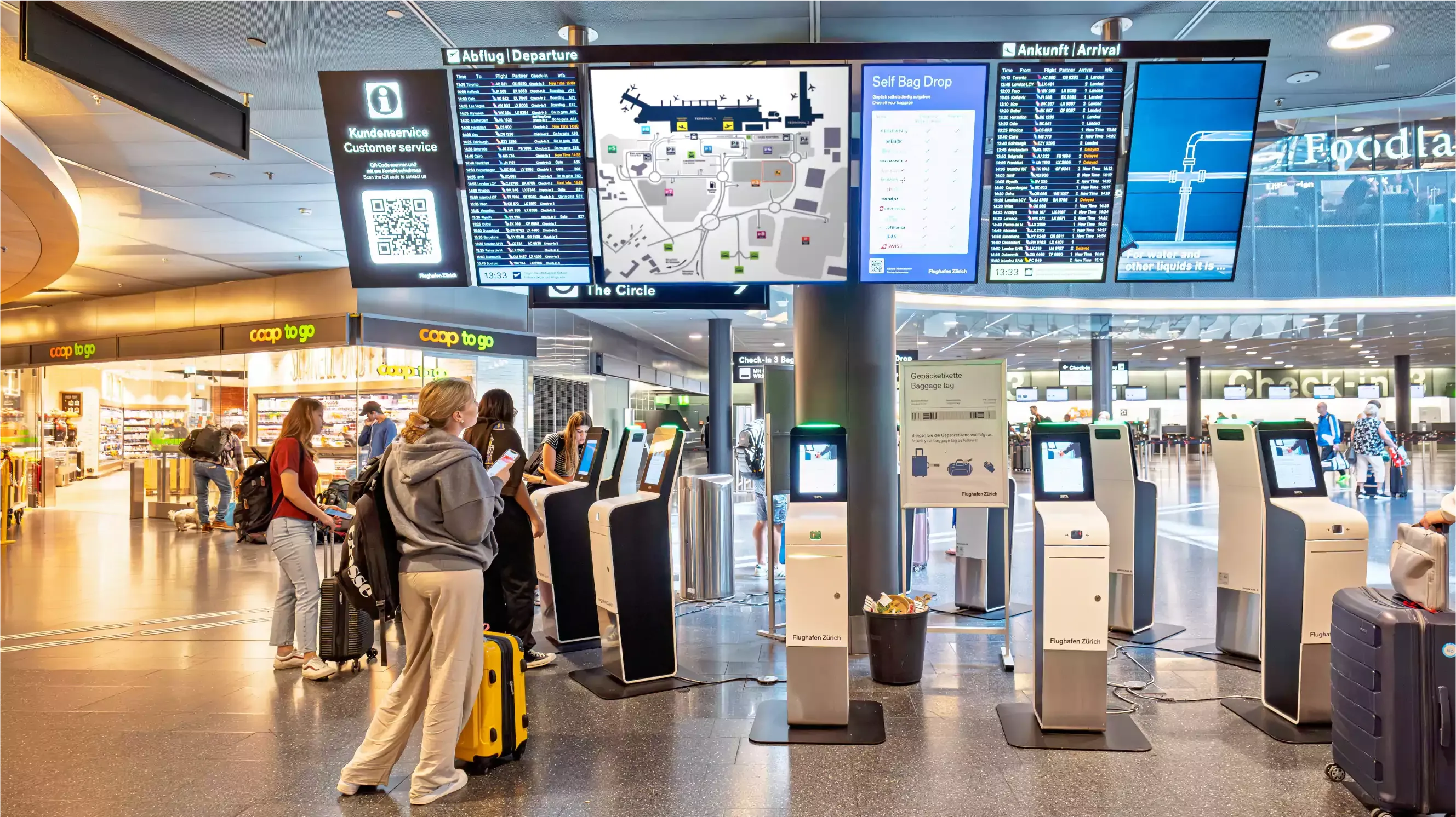
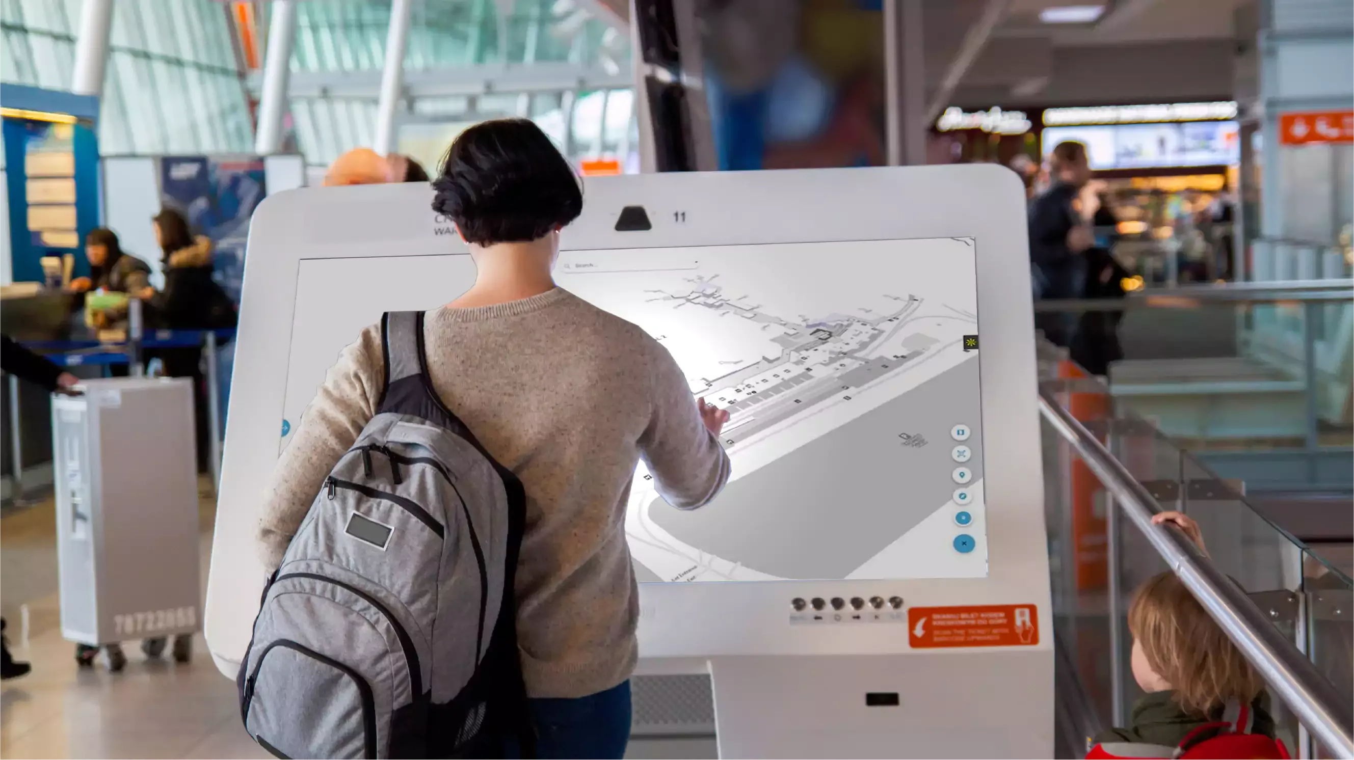
For operations teams, indoor navigation is both a guidance layer and an observability layer. The same signals that make the blue dot steady can reveal where footfall builds and where dwell time stretches beyond normal. When a hallway begins to clog, the system anticipates a queue before it becomes visible to staff and can push alternative routes across channels like mobile web for visitors who scan a QR code, kiosks near decision points, digital signage at escalator landings, and the venue’s app for frequent users. This multi-channel delivery is essential; not everyone downloads an app, and first-time visitors need help just as much as loyal ones.
Crucially, these insights are useful only if they lead to action. A good system turns analytics into decisions: increase staffing at a checkpoint, reverse escalator direction during an event surge, or temporarily highlight a different entrance that balances flow. In planning cycles, the digital twin becomes a safe sandbox. Teams can test “what happens if we move this kiosk?” or “what if we open a temporary gate near this junction?” before committing time and budget to physical changes.
Privacy, trust, and the ethics of indoor analytics
Indoor analytics can feel uncomfortable when they overreach. The privacy-first approach focuses on movement, not identity. It minimizes collection, aggregates data to show patterns rather than people, limits retention to what is operationally necessary, and makes any account-based features an explicit opt-in. When a system is designed this way from the outset, it earns the right to be helpful without being invasive. Visitors get the benefit of real-time guidance; operators get the benefit of reliable, decision-ready information; and nobody feels surveilled.
A pragmatic path from floor plan to live guidance
Most successful deployments follow a simple rhythm. It begins with map ingestion: CAD or BIM drawings, or even well-structured PDFs, are converted into the indoor graph that will power navigation. Instrumentation comes next, which is less about blanket coverage and more about strategic placement. Sensors belong where choices are made and where bottlenecks form, while existing Wi-Fi or BLE can carry a lot of the load elsewhere. A short pilot period then calibrates models to the venue’s real rhythm: shift changes in a hospital, event nights in an arena, morning peaks at a campus, or holiday travel waves at an airport. When the pilot demonstrates stable positioning and meaningful improvements against agreed metrics, the system goes live across channels, so the benefits reach everyone, not just app users.
What changes when journeys get smarter?
In an airport, fewer passengers miss connections because routes adapt to disruption in real time, and security lanes are balanced before they visibly overload. Retail areas benefit because guidance highlights options tucked away from the main concourse, distributing dwell time more evenly. In healthcare settings, on-time arrivals increase and stress decreases because patients receive directions that are both step-free and straightforward, and staff spend less time escorting lost visitors. In retail and mixed-use destinations, tenants become easier to find, pop-ups gain visibility when they matter, and managers see what genuinely draws people rather than guessing from sales alone. Museums, arenas, and campuses see smoother entries and exits and can offer inclusive paths for visitors who need them without making those visitors feel singled out.
Measuring what matters: from blue dots to business outcomes
Indoor navigation only earns its place if it improves outcomes, you already care about. That means quantifying journey time saved between common pairs such as check-in to gate or entrance to clinic, tracking on-time arrival rates for flights, appointments, and classes, and calculating queue minutes avoided during predictable peaks. Accessibility deserves the same rigor: measure the proportion of step-free journeys completed without assistance and the reduction in staff time spent on ad-hoc escorting. Revenue impacts are no longer guesswork when you can tie improved discoverability and dwell in high-value zones to actual transactions. Define baselines during the pilot, establish reporting that stakeholders trust, and keep optimizing once the system is live.
Choosing an indoor navigation partner with a clear head
The market uses similar language, so it helps to look beyond claims and focus on proof. Ask to see positioning stability in the busiest areas of your venue, not just in a quiet corridor. Confirm that routing truly adapts when assets fail or conditions change, and that accessibility options are intrinsic rather than add-ons. Look for a privacy model that is specific, not vague, and for multi-channel delivery that reaches visitors who will never install an app. Make sure the digital twin is easy to update as your layout evolves, and that operations teams can run “what-if” experiments without a ticket to engineering. Above all, expect time-to-value measured in weeks, with a pilot that defines and then meets joint KPIs.
Visual positioning with ARCore and ARKit in 2026
The biggest shift since the last edition of this guide is that camera-frame matching has matured enough to replace BLE in many retail and hospitality footprints. Visual positioning, sometimes called VPS, uses the phone's existing camera to match what it sees against a pre-scanned 3D model of the venue. Modern phones running ARCore (Android) or ARKit (iOS) can hold a position within roughly one metre indoors once the user briefly points the camera around at startup, which is closer to true GPS-grade accuracy than any beacon network we have shipped against.
The trade is battery and venue effort. A continuous AR session typically consumes 10 to 20 percent of phone battery per hour, so well designed apps drop into a low-power mode the moment the user is on a straight corridor and only re-engage the camera at decision points. On the venue side, a one-off photogrammetry scan of public areas replaces the recurring cost of replacing 200 to 800 BLE beacons every three to four years. For new builds and major refreshes in 2026, we now recommend visual positioning as the default for the public-facing journey, with BLE retained only where camera use is impractical (back-of-house, behind-the-counter staff workflows, or venues with light-sensitive areas).
AR navigation: phone overlays versus Hololens-class wearables
Once positioning is good enough, the next question is how to render the directions. Two modes matter today. Phone-screen overlay puts a translucent arrow on top of the live camera feed, exactly like Google Maps Live View outside. It is the right choice for one-off visitors at airports, hospitals, and stadiums because no extra hardware is needed and the UX is now familiar. The downside is the visitor has to walk with the phone held up; we recommend overlay only at decision points (turn here, descend here) and a normal 2D map for the long straights in between.
Hololens-class wearables, including the newer mixed-reality headsets from Apple and Meta, are a different category. They make sense in staff workflows: a maintenance technician routed to a specific valve in a basement plant room, a nurse routed to the correct outpatient bay, an airport ground handler routed across an apron. The 2026 deployments we have seen succeed are all staff-facing rather than visitor-facing; consumer adoption of wearables is still too low to justify designing the visitor journey around them. For visitor wayfinding, plan for phone overlay first and treat wearables as a future-facing pilot rather than a production tier.
Accessibility wayfinding aligned to WCAG 2.2
Accessibility used to mean stair-free routing. In 2026 it covers the full sensory and cognitive load of moving through a building, and the WCAG 2.2 specification (published by the W3C) is the right baseline to design against. Four patterns deserve attention. First, voice-led navigation, where the route can be spoken turn by turn through the phone's speaker or paired headphones for visitors who cannot, or do not want to, look at a screen while walking. Second, screen-reader compatible maps, where every map element has a semantic label so VoiceOver and TalkBack can describe corridors, lifts, and points of interest in sequence.
Third, wheelchair-routable paths that explicitly prefer ramps, level transitions, automatic doors, and avoid revolving doors and steps. The routing engine treats these as hard constraints, not preferences, when a user opts in. Fourth, sensory considerations: an option to prefer quieter corridors away from public-address speakers and reflective surfaces, useful for visitors with autism, hearing aids, or sensory sensitivities. Done together, these stop being a separate accessible mode and become part of the default routing options every visitor can choose. That is the bar WCAG 2.2 sets for indoor wayfinding, and it is the bar Ariadne's indoor navigation platform is built against.
Vertical-specific wayfinding patterns
Most of this guide treats indoor navigation as one problem, but the right pattern differs sharply by venue. Four sub-cases are worth calling out, because the dominant journey, the handoff to physical signage, and the success metric are not the same.
Airports: signage handoff at the jet bridge
At an airport, the digital route runs from the kerb to the gate, then hands off to physical signage and crew direction the moment the passenger reaches the jet bridge. Trying to keep the visitor in-app past that point hurts more than it helps; phones go into airplane mode, hands fill with bags, and overhead displays take over. Glasgow Airport's deployment of Ariadne's wayfinding platform follows this rule: turn-by-turn through security, gate-area dwell heatmaps for the ops team, and a clean handoff to the airline's boarding flow at the gate threshold. The metric that matters is misconnection rate, not app session length.
Hospitals: outpatient flow and stress reduction
In hospitals, the unique constraint is that visitors are often unwell, anxious, or carrying for someone who is. The journey usually starts at a car park or main entrance and ends in a specific outpatient clinic three or four floors away. The right pattern is a short, calm, voice-optional route that respects accessibility from the first step, plus a clear option to ask for a human escort if the visitor wants one. Hospitals that pair the app route with discreet QR-code signage at lift lobbies see the strongest reduction in late arrivals; pure in-app routing leaves out the elderly visitor without a smartphone.
Shopping centers: anchor-to-anchor routing
In an Einkaufszentrum (mall) context, most visitors arrive with a destination in mind, usually an anchor tenant. The right primary journey is anchor-to-anchor routing: from the car park to anchor A, then from anchor A to anchor B, with mid-tier stores surfaced contextually along the route. This is materially different from "find the closest shoe shop", which is what most mall apps default to. Centres in Frankfurt and Stuttgart running Ariadne's footfall and wayfinding stack use anchor-to-anchor as the default route, then layer dwell-time and footfall data on top to suggest dwell-friendly detours. Conversion lift in the mid-tier units near those detour points is the metric to track.
Stadiums: gate-to-seat as the only journey
Stadiums and arenas have one dominant journey, gate-to-seat, repeated by tens of thousands of people inside a 30-minute window. The pattern is unusual because the route is short, the volume is enormous, and accuracy at the seat-block level matters more than corridor-level precision. The system should pre-route the visitor from the moment the ticket is scanned at the gate, suggest the closest concourse to their seat block, and stop guiding them the moment they enter the correct seating bowl. Post-event, the same engine reverses to manage egress flow. The success metric is time-to-seat after gate scan, and the failure mode is over-routing visitors who already know the venue.
The destination: navigation as a quiet co-pilot
The future of indoor wayfinding is not flashy. It is calm, respectful, and responsive. When signals are reliable, maps are alive, and routing is adaptive, navigation fades into the background and people simply get where they need to go. Operators stop chasing problems and start shaping better experiences. That is the promise of indoor navigation done well.
If you are exploring a privacy-first indoor positioning and digital wayfinding solution, Ariadne specializes in turning floor plans into living, real-time guidance that works across app, web, kiosks, and digital signage. By combining accurate sensing, continuously updated digital twins, and human-friendly routing, Ariadne helps airports, hospitals, retail destinations, museums, arenas, and campuses deliver smoother journeys and measurable operational gains. Share your floor plans and goals, and we’ll map a small, sensible pilot with clear KPIs then earn the rollout.